
Walk along the river Rienz to Bruneck

Bruneck and surroundings
Add to favourites
Category
Difficulty
Easy
Duration
1:30
in hours
Distance
3.8
in km
Suggested period
Jan
Feb
Mar
Apr
May
Jun
Jul
Aug
Sep
Oct
Nov
Dec

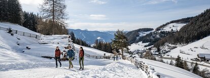
This leisurely walk next to the river Rienz leads from St. Lorenzen/San Lorenzo to Bruneck/Brunico.

Route data
Easy
Distance
3,8 km
Duration
1 h 30 min
Ascent
30 m
Decent
30 m
Physical condition
Scenary
Highest point
835 m
Lowest point
805 m
Suggestions
As the hiking trails can be icy, it is advisable to use microspikes.
Directions

Starting point is the car park in the village center. From there the trail no. 2 leads first to the Rienz promenade. With a view to the magnificent mountains of Rieserferner you walk on flat paths towards Bruneck. Within approx. 40 minutes you reach the small medieval town of Bruneck. Return to St. Lorenzen on the same path. The trail can be done, of course, the other way round as well.

How to get there
Public transport from Mobility Center Bruneck/Brunico:
With the Citybus 420.2 to St. Lorenzen/San Lorenzo, bus stop "Bahnhof/Stazione".
You might be interested in
Discover related tours
Bruneck and surroundings
Hiking to the Lercher Alp Hut
Distance 2,4 km
Duration 2 h 00 min
Ascent 243 m
Decent 0 m
Bruneck and surroundings
Kaiserwarte
Distance 2,1 km
Duration 44 min
Ascent 166 m
Decent 0 m
Plan de Corones > Passo Furcia
Distance 3,3 km
Duration 1 h 30 min
Ascent 5 m
Decent 529 m
Status
closed
Bruneck and surroundings
Tales and stories of Mount Kienberg
Distance 11,8 km
Duration 3 h 28 min
Ascent 417 m
Decent 417 m
Gais | © Harald Wisthaler, Bruneck Kronplatz Tourismus
Intermediate
Add to favourites
Bruneck and surroundings
Gais - Castle Kehlburg - Amaten - Gais
Distance 8,3 km
Duration 3 h 00 min
Ascent 510 m
Decent 510 m
Bruneck and surroundings
Saint Valentine church
Distance 2,6 km
Duration 1 h 00 min
Ascent 26 m
Decent 26 m