
Hiking Trail Haidenberg

Bruneck and surroundings
Add to favourites
Category
Difficulty
Easy
Duration
1:00
in hours
Distance
2
in km
WSEN
Suggested period
Jan
Feb
Mar
Apr
May
Jun
Jul
Aug
Sep
Oct
Nov
Dec

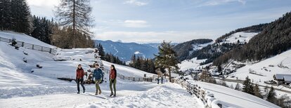
A beautiful walk, suitable also for families, through the green landscape, to the mountain inn Haidenberg.

Route data
Easy
Distance
2,0 km
Duration
1 h 00 min
Ascent
343 m
Decent
0 m
Physical condition
Scenary
Highest point
1.304 m
Lowest point
961 m
Directions

From the parking near the Kneipp path in Stefansdorf/S. Stefano, walk along a short stretch of forest road, then, following the path no. 4 through the woods for about 1 hour, reach the Inn Haidenberg (1,280 m). Alternatively you can walk to Haidenberg on the asfalt road (suitable also for strollers).

How to get there

Public transport from Mobility Center Bruneck/Brunico:
With the Citybus 420.2 to Stefansdorf/Santo Stefano, bus stop "Abzweigung Reischach/Bivio Riscone" or "Harrasacker".

You might be interested in
Discover related tours
Bruneck and surroundings
Pfalzen / Falzes – Irenberg
Distance 4,9 km
Duration 2 h 00 min
Ascent 126 m
Decent 126 m
Plan de Corones > Passo Furcia
Distance 3,3 km
Duration 1 h 30 min
Ascent 0 m
Decent 529 m
Status
closed
Marmot-Walk | © Tourismusverein Kiens, Kiens
Intermediate
Add to favourites
Bruneck and surroundings
Marmot walk
Distance 10,2 km
Duration 3 h 40 min
Ascent 699 m
Decent 699 m
Bruneck and surroundings
Gaisinger "Waalweg"
Distance 5,3 km
Duration 2 h 00 min
Ascent 140 m
Decent 140 m
Bruneck and surroundings
Hiking Trail Concordia 360°
Distance 2,2 km
Duration 37 min
Ascent 58 m
Decent 58 m
Kofler am Kofl | © Thomas Conti, Bruneck Kronplatz Tourismus
Intermediate
Add to favourites
Bruneck and surroundings
Kofler am Kofl
Distance 2,5 km
Duration 1 h 30 min
Ascent 360 m
Decent 0 m