Hiking tour to the Walder Alp Hut

Bruneck and surroundings
Add to favourites
Category
Difficulty
Easy
Duration
1:00
in hours
Distance
1.6
in km
Suggested period
Jan
Feb
Mar
Apr
May
Jun
Jul
Aug
Sep
Oct
Nov
Dec

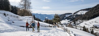
From the hamlet of Ellen, a hike leads to the traditional alpine tavern Walderalm, surrounded by flowering meadows, which invites you to take an enjoyable break with a view on the Bruneck valley basin.

Route data
Easy
Distance
1,6 km
Duration
1 h 00 min
Ascent
370 m
Decent
3 m
Physical condition
Scenary
Highest point
1.930 m
Lowest point
1.560 m
Directions
From the parking lot Kreuzner follow the wide, slightly ascending forest path (accessible with strollers) or the well-marked but a bit steeper path no. 67 (not suitable for strollers) in direction Astjoch/Cima Lasta and reach the hut Walderalm after approximately one hour of walk.
How to get there

Public transport from Mobility Center Bruneck/Brunico:
With the rail replacement service B400, the Citybus 420.2, the bus no. 401 or 460 to St. Lorenzen, bus stop Bahnhof and then with the Citybus no. 424 to Ellen, bus stop Kreuzner.

You might be interested in
Discover related tours
Bruneck and surroundings
Tales and stories of Mount Kienberg
Distance 11,8 km
Duration 3 h 28 min
Ascent 417 m
Decent 417 m
Plan de Corones > Passo Furcia
Distance 3,3 km
Duration 1 h 30 min
Ascent 0 m
Decent 529 m
Status
closed
Bruneck and surroundings
Kaiserwarte
Distance 2,1 km
Duration 44 min
Ascent 166 m
Decent 0 m
Bruneck and surroundings
Family hike to the "Mühlbacher Badl"
Distance 1,0 km
Duration 23 min
Ascent 103 m
Decent 0 m
Aschbach Alm hut and Redensberg Alm hut | © Schuster Barbara, Tourismusverein Antholzertal
Intermediate
Add to favourites
Bruneck and surroundings
Aschbach Alm hut and Redensberg Alm hut (not managed)
Distance 3,4 km
Duration 1 h 52 min
Ascent 578 m
Decent 11 m
Status
closed
Dolomites | © Skirama Kronplatz, Bruneck Kronplatz Tourismus
Intermediate
Add to favourites
Bruneck and surroundings
Plan de Corones > Pracken > Malga Oberegger > Casola
Distance 8,3 km
Duration 3 h 30 min
Ascent 0 m
Decent 1.119 m
Status
closed