
Family hike through the "LandArt" trail

Bruneck and surroundings
Add to favourites
Category
Difficulty
Easy
Duration
0:37
in hours
Distance
2.3
in km
Suggested period
Jan
Feb
Mar
Apr
May
Jun
Jul
Aug
Sep
Oct
Nov
Dec

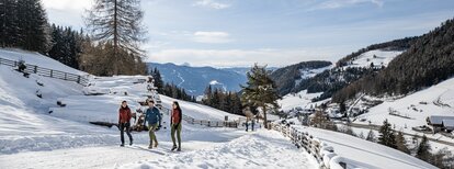
The LandArt Trail in Pfalzen is a wonderful, family-friendly hike that starts at the Pfalzen sports zone. The circular trail takes about an hour and leads through a picturesque landscape adorned with artworks in nature. The art installations along the trail invite you to experience nature creatively and offer a special atmosphere that delights both adults and children. The trail is easy to walk and perfect for a relaxing outing with the whole family.

Route data
Easy
Distance
2,3 km
Duration
37 min
Ascent
36 m
Decent
49 m
Physical condition
Scenary
Highest point
996 m
Lowest point
948 m
How to get there

Coming from Innsbruck/Brenner (A): Drive on the Highway of Brenner (A22) until the exit Brixen/Pustertal, then go on along the SS49-E66 for about 50kms until you arrive in Olang/Valdaora.

Coming from Lienz (A): You can reach us also padding by Lienz in Westtyrol (A). You have to cross the Austrian-Italian border between Ahrnbach and Winnebach (B100-E66) and drive on the SS46-E66 until Olang/Valdaora

Coming from Bozen: Highway of Brenner (A22) until the exit Brixen/Pustertal, then go on along the SS49-E66 for about 50kms until you arrive in Olang/Valdaora.

You might be interested in
Discover related tours
Panoramic trail Pfalzen / Falzes | © Harald Wisthaler, Bruneck Kronplatz Tourismus
Intermediate
Add to favourites
Bruneck and surroundings
Panoramic trail Pfalzen / Falzes
Distance 5,2 km
Duration 2 h 00 min
Ascent 189 m
Decent 189 m
Welsberg Monguelfo | © TG Gsiesertal Welsberg Taisten_Kamilla Photography, Dolomite Region Gsiesertal Val Casies
Intermediate
Add to favourites
Bruneck and surroundings
Camino de Santiago, stage Monguelfo – Valdaora – Nessano – Brunico
Distance 21,3 km
Duration 5 h 51 min
Ascent 441 m
Decent 695 m
Status
closed
Bruneck and surroundings
Saint Valentine church
Distance 2,6 km
Duration 1 h 00 min
Ascent 26 m
Decent 26 m
Plan de Corones > Passo Furcia
Distance 3,3 km
Duration 1 h 30 min
Ascent 5 m
Decent 529 m
Status
closed
Bruneck and surroundings
Concordia Panorama Trail
Distance 2,0 km
Duration 1 h 00 min
Ascent 30 m
Decent 30 m
Aschbach Alm hut and Redensberg Alm hut | © Schuster Barbara, Tourismusverein Antholzertal
Intermediate
Add to favourites
Bruneck and surroundings
Aschbach Alm hut and Redensberg Alm hut (not managed)
Distance 3,4 km
Duration 1 h 52 min
Ascent 578 m
Decent 7 m
Status
closed